

|
|
HISTORY OF ARIZONA AND NEW MEXICO, 1680—1888CHAPTER XXXI.
COUNTIES AND TOWNS OF NEW MEXICO.
|
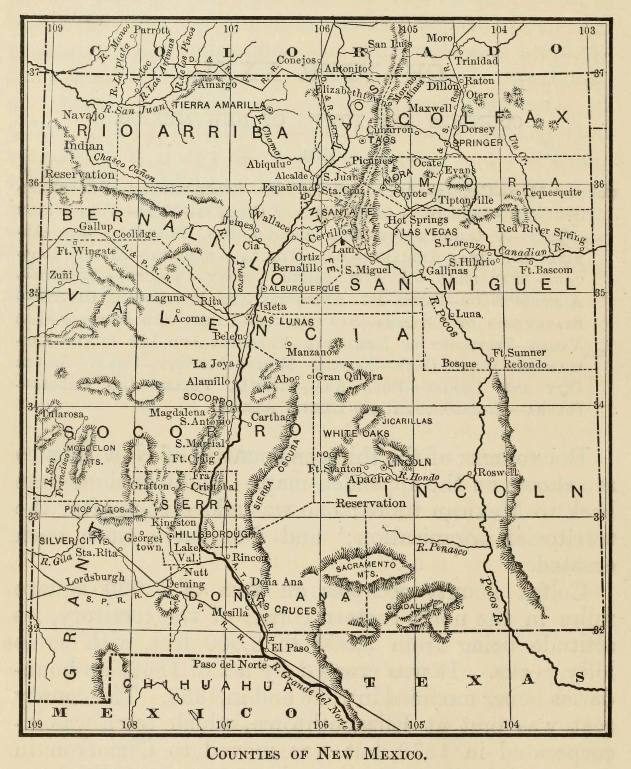 |
Boundaries of the thirteen counties of New Mexico are shown on the
appended map. Eight of them date back to Mexican times; one was added soon
after the territorial organization; and four have since been created.
Colfax county occupies an area of 7,000 square miles in the
north-eastern corner of the territory, its altitude being from 5,500 to 8,000
feet, with some lofty peaks. It was created by act of 1869, its boundaries being modified in 1876 and in 1882. The county seat was first at
Elizabethtown, which town was incorporated in 1870, but was moved to Cimarron
in 1872, and finally to Springer in 1882. In 1876-8 the county was attached to
Taos for judicial purposes. About half the area is mesa or prairie land,
affording excellent grazing, and supporting in 1880 about 29,000 cattle and
65,000 sheep, the numbers having greatly increased since that date, 187,000 and
86,000 being the figures in 1883. Along the watercourses are numerous narrow
tracts, successfully cultivated by irrigation. There are over half a million
acres of coalfields, and the coal is somewhat extensively worked in the region
of Raton. The mountains are covered with pine, affording lumber of fair quality
in considerable quantities. Of gold from the Moreno placers and Ute Creek and
other quartz mines several millions of dollars have been produced since 1868,
and copper is also found. Over half the county is included in the famous
Maxwell rancho, or land grant of Beaubien and Miranda, and here the Jicarilla Apaches and Ute bands had their homes for many years, as
related in an earlier chapter. The Atchison, Topeka, and Santa Railroad, the
first to enter the territory, crosses Colfax from north to south, and on its
line are the leading towns. The population in 1880 was 3,398,
and is now perhaps 5,000. The total assessed value of property in 18b3
was $5,437,640, the largest item being that of livestock. Raton, with over
2,000 inhabitants, is the largest town, being of modern or railroad origin. Its
prominence arises from the proximity of the coal mines, to which a branch road
extends, and from the location of the railroad shops here. The town has good water-works, good schools, two newspapers—the Guard, and
News and Press—the only ones published in the county, and it aspires to future
prominence as a manufacturing centre. Springer, the
county seat, had but 34 inhabitants in 1880, but is now a thriving village,
with a fine court-house and a cement factory, being
also the shipping point for a large territory east and west. Elizabethtown and
Cimarron, formerly honored as county seats, had respectively 175 and 290
inhabitants in 1880. The former is a mining town in the Moreno districts; and
the latter, formerly known as Maxwell’s rancho, may be considered the oldest
settlement in the county. Colfax has a smaller proportion of native, or
Mexican, population than most parts of the territory.
Mora county, lying south of Colfax, with an area of 3,700 square miles,
was created in 1860, being cut off from Taos, and including Colfax down to
1869. There were slight changes of boundary in 1868, 1876, and 1882. The county
seat has been Mora, or Santa Gertrudis, from the first. The population was
9,751 in 1880, and may be nearly 12,000 now, a majority being of Spanish
origin. The average elevation is 4-7,000 feet, the mountainous parts being in
the western fourth, while the mesa lands occupy three fourths in the east.
These grazing lands resemble those of Colfax in a general way,
but are more cut up by ravines and timbered belts affording good
protection from the winds. Thirty-eight thousand cattle and 78,000 sheep are
noted by the assessor in 1883, but these figures are more than doubled by other
authorities. The census of 1880 gives 576 farms, with an average extent of 101
acres, not only cereals but small fruits and sugar beets being successfully
produced. In agricultural products for 1880 Mora, with $301,190, stood second
in the list of counties. The total assessment in 1883 was $1,540,451. Mineral
resources, known to be considerable, have been but very slightly developed,
because the deposits are all on the unsettled Mora grant of some 800,000 acres.
The railroad crosses the county from north to south, the principal stations
being Ocate, Evans, Wagon Mound, Tiptonville, and
Watrous. The latter has about 500 inhabitants, a newspaper—the Pioneer,
formerly published at Tiptonville—and is the point of distribution for stock-men in most parts of the county. Mora, the county seat and the oldest town—dating from the issue of the land
grant in 1835—had a population of 915 in 1880, probably scattered over a
considerable area. Fort Union is one of the best known military posts of the territory, having been much of the time the military
headquarters. The reader will recall the unsuccessful attempt of the confederates
to capture this fort in 1861-2.
Taos county covers a tract of about 1,400 square miles in the upper Rio
Grande valley, directly west of Colfax and Mora. It was one of the original
Mexican counties, including, as bounded by the act of 1852, all
of the present counties of Colfax and Mora, a wide strip of Rio Arriba
extending westward to the Arizona line, and all that part of the territory
since annexed to Colorado. Thus, from being one of the largest it has become
one of the smallest counties. It takes its name from the pueblo of Taos, one of
the grandest found by Coronado’s expedition of 1540, and still standing as the
chief attraction of the region for visitors of today. Another of the ancient
pueblos, that of the Picuries, still stands as in the
past centuries. The chief town is also Taos—known as Fernandez de Taos or Don
Fernandez de Taos, a corruption, I suppose, of San Fernando de Taos—situated
several miles from the old pueblo, having a population of about 2,000, and
having always been the county seat The average altitude of the county is 6,000
feet, and it is one of the best watered and timbered regions of the territory,
having always been famous for its agricultural excellence. That very much
greater progress has not been made in this direction is due chiefly to the fact
that four fifths of the 12,000 inhabitants are of Mexican origin, and cling to
their primitive methods of cultivation; yet Taos produced £386,2S3 in
agricultural products in 1880, standing first in the list of counties. The
assessment was $583,810 in 1883, when there were about 2,000 cattle and 83,000
sheep. There were in 188O, 888 farms, averaging 73 acres in size. The Taos
mines have been more fully developed than others in the north, with good
results from both quartz and placers, as elsewhere noted. The Denver and Rio
Grande narrow-gauge railroad extends through the county, or along the western
border, from north to south, affording easy access to what has been a
comparatively isolated region; and the result in respects of immigration from
Colorado has already been felt. Taos seems destined to be in the future as in
the past one of the garden-spots of the territory. There are no towns of much
importance, outside of the county seat, not mentioned in the census of 1880;
but among the small hamlets may be mentioned Ranchos de Taos, with a fine
flouring mill, Arroyo Hondo, Arroyo Seco, San Antonio Cerro, Castilla, Ojo Caliente, Red River Town, and Calabria.
Rio Arriba, or ‘Up the River’ county occupies an area of about 12,500
square miles in the north-western corner of the territory, lying west of Taos.
It was one of the old Mexican counties, but originally and as organized in 1852
it did not include the northern strip along the San Juan. This strip was in
1861 cut off from Taos and organized as the county of San Juan, with the seat
at Baker City; but the act was repealed in 1862; and in 1880 the tract was
added to Rio Arriba. (In 1887, as this goes into type, San Juan has been again
created.) The county seat was in 1852 fixed at San Pedro Chamita; but moved to
Los Luceros in 1855, to Alcalde in 1860, and finally,
in 1880, to Las Nutrias, which was renamed Tierra Amarilla. The average
altitude is nearly 7,000 feet. In the southeastern parts, near the Rio Grande,
this county resembles Taos, and has all the agricultural advantages of its
neighbor in respect of soil, water, and productions. Another fine agricultural
tract, which in recent years is rapidly being filled up with settlers, is that
in the valleys of the San Juan and Las Animas, in the north-west. In 1880 the county had 915 farms —heading the list—averaging
67 acres in size, and yielding $176,641 of farm products. In 1883, according to
the assessor’s report, its 80,054 acres were valued at $87,282; there were
13,791 cattle and 171,107 sheep, not including the extensive flocks of the
Navajos; and the total assessment was $788,180. Natural advantages for farming
and stock-raising are excellent, but only to a comparatively slight extent
utilized; while the mineral resources, known to be large, have been still less
developed, though in late years mines are successfully worked in several
districts. In the extreme west the Navajos have their immense but somewhat
barren reservation, as recorded in other chapters; while in the eastern
regions, about Abiquiú and Tierra Amarilla, the Jicarillas and Utes formerly roved and had their agencies.
The narrow-gauge railroad from Colorado has its terminus at Española; while
another branch extends through the northern borders to and beyond Amargo, where coal mines are worked. Tierra Amarilla, the
county seat, is but a small village, and the county has as
yet no towns of any special importance, or of more than a few hundred
inhabitants, except Santa Cruz, which is said to have had 1,000 in 1883. The
total population in 1880 was 11,023, but the number has since been considerably
increased by immigration. It will be remembered by the reader that Rio Arriba
has played a prominent part in the country’s early annals. Here are seen the
wonderful cliff dwellings, built by the Pueblo tribes long before the Spaniards
visited the province. Here are the aboriginal pueblos of San Juan, Santa Cruz,
and Santa Clara. Here Onate in 1599 fixed his capital, at San Juan de les
Caballeros, at the junction of the Rio Grande and Chama; and here he proposed
to build the great city of his province, though circumstances required a change
of plan, and the town was built at Santa Fe. Under Spanish rule Santa Cruz de
la Canada was a more or less prosperous villa, ranking
among the first, with Santa Fe and Alburquerque, in
population.
Bernalillo county lies south of Rio Arriba, having an area of some 6,500
square miles, a width of over 70 miles in the great valley, extending westward
to the Arizona line, and eastward in an absurd little strip, far enough to make
an entire length of about 250 miles This was one of the original counties of
1852 and earlier, but its boundaries were changed in 1870. The county seat in
1854 was changed from the ranchos to the town of Alburquerque,
where it has since remained, though in 1878 an election for a change was
authorized. The north-eastern portion was formerly Santa Ana, with seat at
Santa Ana and later Peña Blanca; but this little county—also one of the
original ones—was merged in Bernalillo by act of 1876. In wealth and population
this has always been one of the leading sections of the territory. The rich
alluvial lands of the Rio Grande bottom, having for 80 miles an average width
of five miles, furnish unsurpassed advantages for agricultural operations; and
the region is especially noted for its grapes and small fruits. In 1880 there
were only 112 farms, with 3,821 acres of improved land, producing $94,730. In
1883 the acreage is given as 116,037, valued at $1,160,370. Thus the farming lands have not yet been very fully utilized. Back from the river
are the mesa tracts, from ten to twenty miles in width, on which, in 1883,
grazed 475,000 sheep and 41,700 cattle, this county heading the list in the
item of sheep. Mines are successfully worked, especially in the Sandía Mountains, at the New Placers on the Santa Fe
borders, and in the Nacimiento or Jemes district. The
total assessed value of property in 1883 was $4,328,605. The population in 1880
was 17,225, but has considerably increased in later
years. Here, in that part of the great valley adjoining the town of Bernalillo,
was Coronado’s Tiguex, where he spent the winter of
1540-2. Of the ancient pueblos, the county contains Jemes,
Cia, Santa Ana, Cochiti, Santo Domingo, and Isleta; and the
most of the towns of the great valley are settlements with which the
reader is familiar from Spanish times, very slight improvement being noted in
modem times, notwithstanding their exceptional advantages. Alburquerque,
the county seat, is, however, a notable exception. It was founded in 1706,
named for the viceroy of Mexico, and was in Spanish times a flourishing town,
often mentioned in the earlier chapters of this volume. New Mexicans usually
write the name Albuquerque, incorrectly, claiming the duke as governor, and being
greatly at sea respecting the early annals of the villa. The modern city is of
very recent growth, though adjoining the old one, dating from 1880, when the
first locomotive arrived over the Atchison, Topeka, and Santa Fé Railroad. Its
growth has been remarkable, the population in 1880 being 2,315, in 1883 about
3,500, and now claimed to be 10,000, making this the metropolis of the
territory. It is at the junction of the two main lines of railroad, is looking
for the arrival of divers other lines, and bases its
faith in future greatness on its position as a railroad centre,
as well as on the surrounding country’s resources. The new town has many solid
brick blocks, good hotels, fine residences, several manufacturing
establishments, besides the railroad shops; and it takes especial pride in its
schools, including the Alburquerque Academy and the
Indian school, and above all in its clearly manifested spirit of progress. The
second town is Bernalillo, with some 1,800 inhabitants; and the third Golden, with about 1,000.
Santa Fé county, lying east and north of Bernalillo, has an area of
1,250 square miles. It is one of the old counties, with seat of government
always at the city of Santa Fé, though the boundaries were slightly changed by
acts of 1864, 1869-70, and 1882. It is the smallest subdivision of the
territory, of broken and mountainous surface, with a limited area of farming
lands and still more limited supply of water; yet, like most other parts of New
Mexico, blessed with a most productive soil, with great agricultural
possibilities in proportion to its extent. In 1880 there were 313 farms, of 42 acres average size, farm products being
estimated at $59,107. In 1883 its 55,425 acres were valued by the assessor at
$389,265; there were 3,415 cattle and 22,250 sheep; and the total assessment of
property was $2,993,049. The population was 10,867 m 1880,
and has since been largely increased. Mining has been more actively
prosecuted here than in any other northern county, both in early and later
times, the Old and New Placers, Los Cerrillos, and the turquoise mines being
famous, as elsewhere recorded. Manufacturing industry here, as everywhere, is
yet dormant; but the invaluable beds of anthracite coal, with other natural
advantages, promise to make Santa Fé a manufacturing centre of the future. The Atchison, Topeka, and Santa Fé Railroad crosses the county
from east to west, sending out a branch from Lamy station northward to the
capital. The old Indian pueblos are Nambé, Tesuque, Pujuaque, and San Ildefonso. The towns outside of the
capital are small bat flourishing villages in the mining districts, including
Los Cerrillos, Bonanza, Carbonateville, and San
Pedro.
The city of Santa Fé—or San Francisco de Asís de la Santa Fé—the county seat and territorial capital, has been from the first
the centre of the historical happenings recorded in
this volume; and no retrospect is needed here. The town was founded
shortly—perhaps several years—before 1617. Its oft-repeated claim to greater
antiquity, or to be considered the oldest town in the United States, can rest
only on the possibility that it was founded on the site of a small aboriginal
pueblo, and is not a legitimate claim. The city is old enough and interesting
enough without such exaggeration. In Spanish, Mexican, and American times it
has been the capital, metropolis, and commercial centre of the territory; though in the past few years it has, as is claimed, been
surpassed in population by Alburquerque, its chief
rival in the past. It had 6,635 inhabitants in 1880, and the population is now
about 8,000. During the past decade its quaint old, Mexican, one-story adobes
have given way to a considerable extent to brick blocks and residences of
modern style. It has gas and water works, good hotels, and fine churches and
schools. The town is the archbishop’s residence, and the catholics have three churches besides the cathedral, with the San Miguel college of the
Christian Brothers, the convent and academy of Nuestra Señora de Luz. Other educational institutions under protestant auspices are the Santa
Fé academy and the university of New Mexico. At Fort Marcy, in the city, are
the military headquarters. Among relics of antiquity the old adobe palacio
holds the first rank, while the old foundations of the more modern capitol and
penitentiary are also interesting ruins. The town has an altitude of 7,044 feet, and is noted as a sanitarium. With this advantage, its fascinating reminiscences of past centuries, its
central position, its modern spirit of thrift, its extensive mercantile establishments,
and its half-dozen newspapers, Santa Fé looks forward to a future of
prosperity, and has not the slightest idea of ceding its supremacy, political,
commercial, or in any respect, to either Alburquerque or Las Vegas, its most ambitious rivals.
San Miguel county lies east of Santa and Bernalillo, extending eastward
to the Texas line, with an area of 10,600 square miles. It was one of the old
organizations, the boundaries being slightly modified in 1882, and the county
seat being changed from San Miguel to Las Vegas and back again in 1860-2, but
finally fixed at Las Vegas from 1864. San Miguel had a population of 20,638 in
1880, which has been largely increased. Not only is it the most populous and
one of the largest counties, but it is probably in most important
respects—except that of mineral resources, which exist but have not been much
developed—the best and richest. It is watered by the Pecos and Canadian, with
their branches, and contains a large amount of the richest soil, well situated
for irrigation, while certain considerable tracts will produce crops without
artificially supplied water. In 1880 there were 622 farms, averaging 283 acres
in size, and yielding $155,286 in products. In 1883 the valuation of farm
property was $362,443. The mesas of the east and south furnish the best of
grazing ranges, and stock-raising is the county’s industry. In 1883 there were
assessed 47,295 cattle and 385,799 sheep, San Miguel taking second rank in each
item; but in later years there has been a very great development, and now this
county probably heads the list. The western mountains are well wooded, and the
lumber business has assumed comparatively large proportions. In climate and
scenery this region is unsurpassed by any in the territory. The abandoned
pueblo of Pecos—the Cicuye of Coronado in 1540—is an
object of historic interest, and there are many older ruins; the route of the
old Santa Fé trading caravans was nearly identical with that of the modern
railroad; here were fought the battles of the confederate invasion of 1861-2.
Las Vegas, the county seat, though its history dates back only to 1835, has
grown steadily and become the third town in New Mexico, with a population of
about 6,000, and with unlimited aspirations for the future. It is in all
respects a ‘live’ town in its commerce and industries, and perhaps the most
agreeable of all New Mexican towns as a place of residence. It has several good
newspapers, fine public buildings and hotels, gas and water works,
a street railroad, several churches, and exceptionally good educational
institutions, headed by the Jesuit college. The city expects to be a railroad centre when divers inevitable lines shall have been built,
is as well situated as any other town for business, is the distributing point for
an immense stock and farming region in the east, has enterprising merchants,
who already do a large trade, and will by no means yield the palm as commercial
metropolis of the future either to Santa Fé or Alburquerque.
Six miles away, with a branch railroad, are the Las Vegas Hot Springs, with
fine and constantly increasing accommodations for pleasure-seekers and
invalids. The waters are claimed to be unsurpassed, like the climate, and the
property is fortunately controlled by the railroad company, which has the means
and disposition to make this the great resort of the south-western interior.
Outside of Las Vegas the villages are as yet of small
population and of no special importance. One of the smallest and least
important of these is San Miguel del Vado, which in Spanish and Mexican times
was the place most frequently mentioned, and which gave a name to the county.
Valencia county lies south of Bernalillo, having the same length from
east to west, and covering an area of about 7,500 square miles. Its southern
boundary with that of San Miguel forms a dividing line between northern and
southern New Mexico. This is one of the old counties, its boundaries having
been modified by acts of 1870 and 1882. The county seat was in early times at
Valencia, but in 1852 was moved to Tomé, to Belén in
1872, back to Tomé in 1874, and finally to Las Lunas in 1876. The population in
1880 was 13,095, ranking third in the list of counties. There were 239 farms, of 97 acres average size, and farm products were
valued at $102,701. In 1883 the land was assessed at $2,209,323, and all
property at $3,834,20t), there being 12,066 cattle and 217,778 sheep. These
figures would indicate a good showing as compared with those for other parts of
the territory; though most current descriptions point
to a lack of development. The agricultural land is for the most part confined
to the Rio Grande valley, whose length m Valencia is limited, but the grazing
lands are of great extent, though standing in greater need of wells than many
other sections. Mineral resources are almost entirely undeveloped, though
several districts, notably the Manzano, Ladrones, La Joya, and Spiegelberg, have shown good prospects. There are broad coal-fields and fine deposits of salt. Las Lunas,
the county seat and chief town, has a population of about 2,000, and is a
distributing point of some importance. Belen, or Bethlehem, has nearly 1,500
inhabitants. Fort Wingate, in the north-west, is near the Navajo reservation,
and is intended to keep the Indians in subjection. Zuni and Acoma are the
aboriginal pueblos, both famous in early annals. Coronado’s route in the
sixteenth century led him past Zuñi, or Cibola, and the peñol town of Acoma to the great valley, and the Atlantic and Pacific Railroad
follows nearly the same route. The fall of Acoma was the deciding event of Oñate’s conquest, and has been
graphically narrated in Villagrá’s epic. Laguna, by
its situation, gives the overland passenger by rail his best view of a pueblo,
though it is of comparatively modern origin.
Lincoln county, lying south of San Miguel and Valencia, and occupying
the south-eastern corner of the territory, is the largest of the counties, with
an area of 20,000 square miles, and has the smallest population, only 2,513 in
1880. It was created in 1869, being cut off from Socorro, and the boundaries
being defined by act of 1878. The seat was fixed at Rio Bonito, formerly called
Las Placitas, and renamed Lincoln in 1870. The county was for a time attached
to Socorro for judicial purposes. It is watered by the Rio Pecos, the old Río
de las Vacas, and its branches; and the great valley
is thought to possess great agricultural possibilities for the future. In the
east, adjoining Texas, the plains are arid and largely unfit for grazing except
by means of wells. In the western plains and mountain valleys the grazing is
excellent. In 1883 Lincoln headed the list with 81,053 cattle,
and stood sixth with 137,013 sheep. The assessed value of property was
$2,053,176; and 18,283 acres of land were valued at $60,628. In 1880 there were
60 farms, averaging 224 acres in size, and producing $38,749. Rich mines have
been worked in the districts of White Oaks, Nogal, Bonito, Red Cloud, and
others in the western mountains. Among the impediments to progress the most serious
have been Indian troubles, the disorderly character of the population, and the
lack of means of transportation. Here, under the protection of Fort Stanton, is
the Apache reservation, and the field of countless raids in former years. Here
have been the most serious disturbances and ‘rustler’ wars between Texan,
native, and Mexican stock-men, miners, and
desperadoes. And this is the only county that has no railroad, though several
are projected. Lincoln, the county seat, with 500 inhabitants, has no special
importance, except in being the county seat White Oaks, a mining town, has a
population of about 1,000, and is the county metropolis. Roswell is regarded as
the prospective site of an important agricultural centre.
Socorro county covers an area of about 12,000 miles west of Lincoln and
south of Valencia. It originally included all of southern New Mexico; but Dona Ana was cut off in 1852 and Lincoln in 1869; and
the boundaries were otherwise somewhat changed in 1870, 1872, and 1880. The
county seat was removed to Limitar in 1854, but restored to Socorro in 1867. With its long stretch
of fertile alluvial soil in the main valley, and its 4-6,000,000 acres of
grazing lands, this county is believed to have unexcelled advantages for
agriculture and stock-raising, though both industries, and especially the
former, have hitherto been too much neglected. In 1880, nevertheless, there
were 728 farms, averaging 53 acres each, and producing $217,295. In 1883 the
assessment was $330,793 on 393,170 acres; there were 20,430 cattle and 66,615
sheep; and the total valuation of property was $2,450,193. According to Hitch,
in 1882-4 cattle increased from 9,000 to 70,000, while sheep decreased from
300,000 to 100,000. Mining activity dates from about 1881, and in the yield of
silver, gold, and copper Socorro has become one of the leading counties, with
over 50 districts and many remarkably productive mines. With the growth of this
great mining industry the others retrograded at first, but in recent years
there are indications of revival; and a prosperous future seems assured.
Socorro, the county seat, is a flourishing town of over 3,000 inhabitants, with
every sign of becoming a commercial centre of great
importance; and doubtless other settlements will eventually enter the race of
progress, though hitherto all have been content with mere existence. The
railroad down the Rio Grande traverses the county from north to south, two
short branches extend to the mines at Carthage and Magdalena, and here, as
everywhere, several cross-county roads are looked for in the early future. In a
certain sense Socorro may be regarded as the oldest Spanish name in New Mexico,
though it is not quite certain that the pueblo or spot so named in the
sixteenth century by Oñate is exactly the site of the
present town. In this region was the southernmost group of pueblos, noted by
all the early explorers coming from the south, or in the case of Coronado from
the north; and the name Nuestra Senora del Socorro was given in 1598, in
recognition of the succor there found after crossing the southern deserts.
Spanish and Mexican annals deal for the most part only with the line of
settlements along the river, where the early pueblos have long since
disappeared; but in the north-east were several flourishing mission pueblos,
eventually destroyed by Apaches, the ruins of which
are still seen at Abó, Gran Quivira, and other
places.
Grant county occupies the south-western corner of the territory, with an
area of about 7,000 square miles, being bounded on the west by Arizona and on
the south by Mexico. It is a new county, organized by act of 1868. It was then
cut off from Doña Ana, and a small portion of its territory was included in the
Arizona county of 1860-1, before Arizona was organized as a territory. There was
in 1877 an unsuccessful attempt to attach it to Arizona; and the boundary was
slightly changed in 1880. The county seat was originally at Central City, but was moved to Pinos Altos
in 1869 and to Silver City in 1872. This region does not figure in the early
records, except as the Santa Ilita copper mines were
worked to some extent in Mexican and Spanish times. It is essentially a mining
county, the development of which began at Pinos Altos
in 1866, and the yield of which in 1872-81 was about $5,000,000. In this
industry, as elsewhere recorded, it heads the list of New Mexican counties.
Here was the home of the Apaches, and the scene of
many a bloody combat. The population was 4,539 in 1880, and has been doubled since. The native or Mexican element is comparatively small.
There are excellent agricultural tracts, especially in the valleys of the Mimbres and Gila, where about 10,000 acres are cultivated,
the mining camps affording an advantageous market. In 1880, 68 farms, with an
average extent of 144 acres, are noted as producing $145,167. In 1883 the
assessment was $64,350 on 5,052 acres; total valuation of property $2,960,874.
Grazing lands are extensive, of good quality, and somewhat more fully utilized
than in other parts of the territory. In 1883 there were 15,871 cattle and
328,400 sheep. The Southern Pacific Railroad crosses the county from west to
east, with a narrow-gauge branch from Lordsburg to Clifton in Arizona; while
the Atchison, Topeka, and Santa Fé road comes to Deming and has a branch to Silver
City. The county seat, Silver City, is the mining centre,
and though a new town, incorporated in 1878, has a population of 3,000, with
solid brick buildings and all the characteristics of a thriving modem city.
Deming, at the junction of the two great railroad lines, and noted as the only
competing railroad point in the territory, has sprung up since 1880, and has a
population of nearly 2,000, with well-founded aspirations to the position of
county metropolis in the early future. Georgetown, Pinos Altos, Santa Rita, Lordsburg, Shakespeare, and Carlisle are the most prominent
of other settlements.
Doña Ana county covers an area of about 6,700 square miles on the
southern frontier, between Grant on the west and Lincoln on the east. It
comprises a considerable portion of the Gadsden purchase of 1853-4. The county
was cut off from Socorro in 1852, and then included all of southern New Mexico. Besides the cutting-off of the other southern counties, as
elsewhere recorded, the boundary was modified by acts of 1870, 1872, and 1878.
The county seat was originally Doña Ana, but was changed to Las Cruces in 1853,
to Mesilla in 1856, and finally to Las Cruces again in 1882. The population in
1880, including most of Sierra county, was 7,612; and
is now, alone, probably much more. The lower Rio Grande valley is known as the
Mesilla valley, and is a veritable garden-spot, famous not only for its general
crops of grain, but for its vegetables—especially onions—small fruits, and
above all, for its grapes and wine. Its soil is fertile and easily irrigated;
two crops in a year are often raised, and hay can be cut on the mesas any day
in the year. In 1880 there are noted 431 farms, averaging 107 acres, and
producing $175,005. In 1883 the assessment was $474,817 on 36,584 acres; and
the total valuation of property was $1,417,354. Back from the river the mesas
furnish the same advantage for grazing that are found in other regions; but in
1883 only 7,248 cattle and 24,853 sheep are reported. Rich mines have been
worked, especially in the Organos, Jarillas, and Potrillas mountains. The county is traversed by the Southern Pacific Railroad from Deming
to El Paso, and by the Atchison road from Deming to
Rincon, and from Rincon down the Rio Grande to El Paso, so that no region is better
supplied with railroads. Las Cruces, the county seat, has about 1,500
inhabitants, a newspaper, the Rio Grande Republican, and is the business centre. Mesilla, with a population of 1,200, and another
paper, the News, is a close rival. Rincon and Nutt are railroad junction
stations. This section has no early history, except that it was traversed by
all the explorers and travellers between new and old
Mexico. I have not even been able to learn from what particular
Dona Ana the settlement derived its name; probably from the wife of one
of the early explorers or governors. The first settlement of the Mesilla valley
was by a Chihuahua colony, after the boundary survey had left this tract in
Mexico, and before the Gadsden treaty restoring it to the United States.
Sierra county is a new creation of 1884, when it was formed from
portions of Doña Ana, Grant, and Socorro, with county seat at Hillsborough. It
has an area of about 2,100 miles, as I estimate it from the map, though
different figures are given by Hitch and others. On account
of its recent origin no statistics are accessible. It is a mountainous
region, with considerable grazing ranges, which have been comparatively well
utilized, and many fertile though small valleys, which may in time be cultivated.
The main industry is, however, mining, in which the county takes the highest
rank in proportion to its size, and very nearly so without reference to area.
Only a few mines have been developed, notably those of the Lake Valley
district, but these have proved by far the most productive of the territory.
Hillsborough, the county seat, Lake Valley, and Kingston are
connected with the main railroad by a branch from Nutt station, and are
thriving mining centres, of small population as yet;
and the northern settlements are Palomas, Fairview, Grafton, Robinson, and
Chloride. The Cañada Alamosa is known to the reader as the site of a former
Indian reservation; and in the main Rio Grande valley, now traversed by the
Atchison, Topeka, and Santa Fé Railroad, is the famous Jornada del Muerto, an object of terror in early times to all who were
compelled to make the trip between old and new Mexico.