

|
|
HISTORY OF ARIZONA AND NEW MEXICO, 1680—1888CHAPTER XXI.
POLITICAL ANNALS OF ARIZONA.1864-1887.
Now that we have at last reached a period when our
territory has legally a name of its own, it is well to devote a few lines to
that name, mainly for the purpose of correcting prevalent errors respecting its
origin. Arizona, probably Arizonac in its original
form, was the native and probably Pima name of the place—of a hill, valley,
stream, or some other local feature—just south of the modern boundary, in the
mountains still so called, on the headwaters of the stream flowing past Saric,
where the famous Planchas de Plata mine was
discovered in the middle of the eighteenth century, the name being first known
to Spaniards in that connection and being applied to the mining camp, or real
de minas. The aboriginal meaning of the term is not known, though from the
common occurrence in this region of the prefix ari,
the root son, and the termination ac, the derivation ought not to
escape the research of a competent student. Such guesses as are extant, founded
on the native tongues, offer only the barest possibility of partial and
accidental accuracy; while similar derivations from
the Spanish are extremely absurd. The oft-repeated assertion that the original
Spanish form was Arizuma has no other foundation than
a misprint in some old book or map. The name should properly be written and
pronounced Arisona, as our English sound of the z
does not occur in Spanish. Suggestions for the legal name were Arizuma, Arizonia, Pimería, and Gadsonia. Pimería would have been in some respects more
appropriate than Arizona—as being of provincial and not merely local
application—and quite as euphonious.
The territorial act having been passed by congress in
February 1863, and officials appointed by President Lincoln in March, the whole
party of emigrant statesmen, headed by Governor John N. Goodwin of Maine,
started in August for the far west, leaving Leavenworth on September 25th,
Santa Fé November 26th, and Alburquerque December
8th, under the escort of troops from Missouri and New Mexico. It was on the
27th that the party crossed the meridian of 109° into Arizona, and two days
later in camp at Navajo Spring, the government was formally organized in the
wilderness. The flag was raised and cheered; a prayer was said by H. W. Read;
the oath of office was taken by the officials; and a proclamation of Governor
Goodwin was read, in which the vicinity of Fort Whipple, established only a
month earlier by Major Willis of the California column, was named as the
temporary seat of government; and here all arrived on January 22, 1864. In May
the fort was moved some 20 miles to the south-west, and near it by July a town
had been founded on Granite Creek to become the temporary capital. It was named
Prescott, in honor of the historian.
Meanwhile the governor made a tour of inspection in
the south, and other parts of the territory; by proclamation of April 9th three
judicial districts were created, and the judges assigned; the marshal was
instructed to take a census; and an election proclamation was issued on the
26th of May. Accordingly, at the election of July 18th, there were chosen a
council of nine members, and a house of eighteen; also
a delegate to congress in the person of Charles D. Poston. The legislature was
in session at Prescott from September 26th to the 10th of November. Besides
attending to the various routine duties, and passing special acts, some of
which, for this as for other sessions, will be noticed elsewhere, this body
adopted a mining law, and a general code of laws, prepared by Judge Howell, and
called in his honor the Howell Code, being based mainly on the codes of New
York and California. It also divided the territory into four counties under the
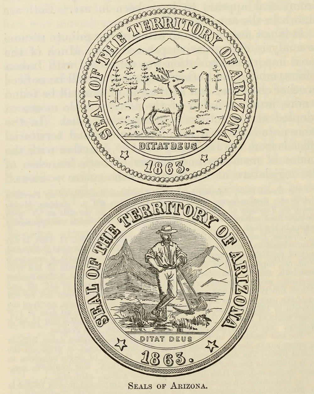
aboriginal names of Pima, Yuma, Mojave, and Yavapai; and adopted a territorial
seal, though for nearly 20 years a different seal appears to have been in use.
Both are shown in the annexed cut.
It is not my purpose to attempt any minute resume or
analysis of legislative proceedings. Much of the most important legislation was connected with Indian affairs, mining, and other
subjects that will be noticed in other chapters; and at the end of this will be
found a note, in which a few of the more notable measures adopted at the
successive sessions are cited. In the same note is given a list of all federal
and territorial officials from the beginning to 1885, together with the names
of members and officers of both branches of the legislature at its thirteen
consecutive sessions. If we credit the statements of political and personal
foes, the members of council and house, like territorial and federal officials,
were for the most part a sad set of rogues and fools; but judging by the record
of their acts, they compare favorably, in respect of honor, ability, and
patriotic devotion to their country’s needs, with representatives of other
territories and states in the west and east.
SEALS OF ARIZONA.
Arizona has been ruled by a line of eight governors
appointed at Washington, as the custom is, more through political influence
than a consideration of the country’s needs, yet as a rule with fairly good
results, as follows: John N. Goodwin in 1863-5, Richard Mc-Cormick in 1865-9, A. P. K Safford in 1869-77, John P. Hoyt, acting, in 1877-8, John C.
Fremont in 1879-81, John J. Gosper, acting, in 1881-2, F. A. Tritle in 1882-5, and C. M. Zulick from 1885. The last, appointed by President Cleveland, is a democrat; all the
rest have been more or less republican in politics.
Governors McCormick and Safford, ruling for the longest terms, were more fully
identified than the others with the real interests of the territory, and
perhaps were more efficient rulers; but the rest seem to have been for the most
part honorable and intelligent men. In a general way their acts call for no
further criticism, favorable or otherwise. One of the number should be well enough known to readers of my history of California; but Fremont
was appointed merely that his chronic poverty might be relieved; and in Arizona
he seems to have done nothing worse than neglect his duties. Delegates in
congress were not less zealous and intelligent men, being in politics union, or
republican, to 1874, democratic to 1884, and then republican again. Though
working with due zeal at Washington, the delegates, as is true for most
territories, have been able to accomplish but little for the advancement of
Arizona, since congress contented itself for the most part with the annual
appropriations for routine expenses.
On the question of a permanent capital the
legislatures of 1864-5-6 could not agree. Representatives of the first district
were not quite strong enough to decide in favor of Tucson, to which town
undoubtedly at that time the honor belonged; but they were able to defeat the
pretensions of Prescott. It was a barren victory, however, since by the
governors proclamation from year to year the legislature was convened at
Prescott as the temporary seat of government. In 1867, however, the tables were
turned, and by a majority of one vote Tucson was made the capital, five
sessions of the legislature being held there; until in 1877 the northern combination
was in turn triumphant, and Prescott has been the capital ever since. Agitation
on the subject is by no means at an end, but Tucson is thought to have but
slight chance of regaining its old position, though a change in favor of
Phoenix or some other town of the central region seems not unlikely in the
future.
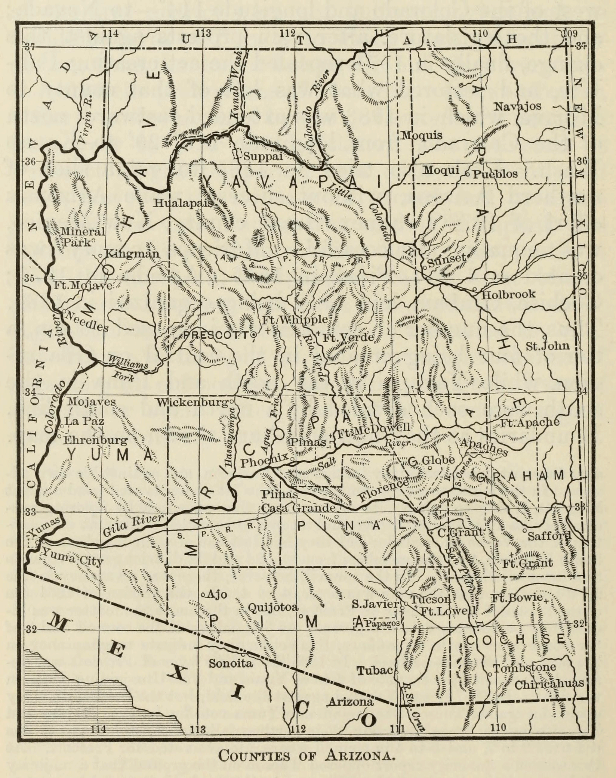
As we have seen, four counties were created in 1864.
In 1865 Pah-Ute county was organized from northern
Mojave; but the next year congress attached the north-western corner of
Arizona—all north and west of the Colorado and longitude 114°—to Nevada; and
the legislature, after vain protests against this change, finally in 1871
repealed the act creating Pah-Ute, and restored what
was left of that county to Mojave, which in 1883 was extended eastward, north
of the Colorado, from longitude 113° 20' to Kanab Wash. Utah also tried in 1865
to get a slice of northern Arizona, without success; while Arizona’s effort of
1877 to annex Grant county, New Mexico, was equally unsuccessful. Maricopa
county was created in 1571; Pinal in 1875; Apache in 1879; Cochise, Graham, and
Gila being organized in 1881. Thus the number of
counties was increased to ten, a tier of four being created in the central or
Gila region, while Yavapai in the north and Pima in the south were each divided
by a north and south line. Boundaries as they now stand are shown on the map.
Yuma alone has retained its original extent, yet not without a boundary
dispute. It had doubtless been the original intention that the Colorado should
be the boundary between Arizona and California, but owing to a peculiar bend of
the river, the line as correctly surveyed from the Gila junction toward San
Diego left a small area south and west of the Colorado opposite Fort Yuma,
technically in California. On this area was a considerable amount of taxable
property, including the ferry buildings. The Arizona legislature rather
indiscreetly asked congress for the land in 1864-5; California took the hint;
the property was taxed by both Yuma and San Diego counties; and a spirited
controversy was carried on from about 1867, each claimant ridiculing the other’s
absurd pretensions. In 1871 there seems to have been some
kind of a decision at Washington in favor of Arizona, and after 1873 I
find no trace of the dispute.
The white population of Arizona—that is, of Arizona
county, New Mexico—according to the somewhat doubtful census of 1860, was
2,421, or perhaps 6,481, including all Mexicans and mixed breeds. During the
disasters of 1861-3, the number was perhaps reduced to 500 or 600. After the
organization of the government, the first territorial census of 1866 showed a
total—excluding Indians—of 5,526; and the second, 7,200 in 1867. The United
States census of 1870 shows a population of 9,658; and the figures in 1872 and
1874 were 10,743 and 11,480, respectively, with a notable increase to 30,192 in
1876. The federal census of 1880 raised the figures to 40,440. For later
years we have no accurate statements; but the population in 1886 should not be
less than 75,000.
In former years, immigration to Arizona depended
mainly on the varying prospects of the mines, though by no means all immigrants
were miners. Of late, however, it has been clearly demonstrated that the
country possesses a great variety of resources, and is capable
of supporting a large miscellaneous population, though here, as
elsewhere, attempts at colonization have met with indifferent success. It is
certain that the land possesses in abundance two of the three great sources of
wealth—mining and agriculture—and to develop them only the industry of man is
needed. Together with her large area of grazing and arable lands, the territory
contains nearly every variety of mineral, and in her valleys can be raised all
kinds of cereals, vegetables, and fruit, the citrus belts of southern Arizona
being destined at no very distant day to rival those of California.
Among the early settlers were the Mormons, who in 1868
had a settlement at St Thomas, in Pah-Ute county, a
region later attached to Nevada. In 1873 the authorities in Utah formed a plan
of colonization, and a pioneer party of 700 men was sent south, intending to
get a start by working on the Texas Pacific Railroad, but became discontented
with the prospect and went home. The project was revived in 1876-7, and a
beginning was made in two districts—on the Upper Colorado Chiquito and on Salt River. At a meeting held at Salt Lake City, in January 1876,
missionaries were present from different parts of Utah, and an organization was effected under Lot Smith as president. The first party
arrived in March at the Sunset crossing, and soon the camps of Sunset, Allen,
Ballinger, and Obed were established. Progress was slow, the first season’s
crop not sufficing for the colony’s needs, and teams having to be sent to Utah for
supplies; but the pioneers were resolute men, and though many, first and last,
abandoned the enterprise, at the end of 1877 the mission numbered 564 souls,
and a year later 587. In 1884 the population is given by the newspapers as
2,507, the chief settlements being Sunset, St Joseph, and Brigham City. The
settlements of this region were in 1878 organized into the Little Colorado
stake of Zion; and at the same time an eastern Arizona stake was organized in
the region about St John, but I have no details on the annals of this stake.
The Salt River settlements, later Maricopa stake,
above Phoenix, were begun in March 1877 by nine families from Utah, organized
at St George by Brigham Young, under Daniel W. Jones as president. There were
71 persons in the colony, the settlement being called successively Camp Utah, Utahville, Jonesville, and finally Lehi. The Utah ditch was
constructed by the incorporated Utah Irrigating and Farming Company. Elder
Jones had some troubles with his flock, the site of the village seems to have
been slightly changed once or twice, and in 1884 the population was less than
200. In January 1878 there arrived from Salt Lake City—part of the members
coming from Idaho—another colony of 77 saints, including the Sirrines, formerly of Brannan’s California colony. They
declined to join Smith in the north, failed to make a satisfactory arrangement
with Jones, and so founded Mesa City, four miles from Jonesville, incorporating
a new company for the construction of a ditch, by which at a cost of $43,000
about 5,000 acres have been reclaimed from the desert. The population was about
600 in 1884. Jesse H. Perkins was presiding elder from October 1878, and A. F.
McDonald president from February 1880, the Maricopa stake being permanently
organized in December 1882.
In 1878 P. C. Merrill and four families left the Jones
colony and founded St David on the San Pedro. In 1879 Joseph K. Rogers with
four families came from the eastern Arizona stake and settled at
Smithville—called Pima from 1883—on the upper Gila in Graham
county. Other settlements formed in 1881-4 were Curtis, Graham,
Thatcher, Central, Layton, and McDonald on the San Pedro. All those
south-eastern establishments were organized in February 1883 into the stake of
St Joseph under Christopher Layton as president. Pima is the chief town, and had in 1885 about 600 inhabitants.
COUNTIES OF ARIZONA
The Mormons have always been regarded as among the
best of Arizona settlers, being quiet, industrious, and economical in their
habits, and not disposed to intrude their religious peculiarities. As a rule polygamy has not been practised,
though there are many exceptions. Their neat adobe houses, orchards,
gardens, and well-tilled fields form veritable oases in the desert. Their lands
are held by the community, work and trade are carried on for the most part on
the cooperative plan, and they even live in community
houses, eating at a common table, though each family has its separate rooms. It
has been their aim to produce all that they eat and wear, sugar-cane and cotton being among their crops. Notwithstanding their community system,
much freedom is conceded to individuals, who may in most respects live as they
please and mingle freely with the gentiles. Less despised and persecuted than
in Utah, they are naturally less clannish, peculiar, and exclusive. In politics
they are nominally democratic, but often divide their vote on local issues, or
put their united vote where it will do most good for
their own interests. As a rule, they are prosperous but not yet wealthy
farmers. Polygamy has led them into trouble, as it has others of their faith,
and in 1884-5 several of their prominent members have been sent to prison.
Of the Salt River valley a
brief description may here be inserted; further mention will be made in a later
chapter. It contains one of the largest bodies of agricultural land between the
states of California and Kansas. It is walled in by mountains,
and watered by a stream which has its source in one of the loftiest
ranges, and is fed by the melting snows and by a hundred tributaries. Near the
river is found a dark alluvial mold, with a depth of from six to fifteen feet,
adapted to cereals and grasses; back from this is a belt of rich loam of
remarkable fertility, and near the foothills the surface is of a light and
porous nature, suited to the cultivation of fruit.
As the average rainfall of Arizona does not exceed ten
inches, the people depend largely on irrigation for the watering of their farms
and orchards. In this valley alone eight main canals had been constructed up to
1887, at an expense of nearly $1,000,000, with a water-way of about 160 miles, and a total carrying capacity of 70,000 miners’ inches,
these being the largest and most expensive works of the kind in the entire territory.
At that date the area reclaimed was estimated at 168,000 acres.
In 1887 not more than 50,000 acres were under
cultivation, of which about 12,000 were in wheat, 16,500 in barley, 15,000 in
alfalfa, 5,600 in fruit, and 1,000 in miscellaneous crops. Of cereals, grasses,
fruits, and vegetables, nearly every variety can be raised; of textile plants,
there are cotton, hemp, jute, and flax; while tobacco and the sugar-cane are also cultivated, the latter being equal to
the best products of Louisiana. Of fruit, the yield is almost unprecedented,
from the fig-tree being gathered two and even three crops a year; while few
portions of this coast are better adapted to the cultivation of grapes, the
product of which reached six or seven tons to the acre. For cattle-raising the
valley is also well adapted, beeves fattened on the alfalfa pastures being
little inferior to the stall-fed animals of the eastern states. Thus, by means
of irrigation and by the enterprise and ingenuity of man, has a lifeless
solitude been transformed into one of the fairest valleys of the Pacific slope.
Among Arizona explorations of later years, Major J. W.
Powell’s adventurous trip down the Colorado deserves especial mention. With a
party of ten, in four boats built expressly for the purpose, Powell left the
railroad and started down Green River, late in May 1869. In the early days of August he crossed the Arizona line, and for about a month
was whirled by the torrent through the tortuous channel of the great canons,
whose precipitous sides towered to a height of several thousand feet—sometimes
over a mile—above the voyagers’ heads. The river proved a succession of rapids
and whirlpools; each days’ advance brought its new perils and toil; hairbreadth
escapes from destruction were of frequent occurrence; one of the boats was
lost; and the supply of instruments, food, and clothing gradually disappeared
in the neverending series of accidents. On the 27th
three of the party resolved to scale the cliffs and make an
attempt to reach the settlements. It is believed that they were killed
by Indians. The rest continued their voyage in two of the boats, and in three
days found succor and reached the mouth of the Río Virgen. From this point
three men went on down the Colorado, while Powell and the rest found their way
to Salt Lake City. In this connection also should be mentioned the surveys of
Captain George M. Wheeler and his corps in 1871—8, by which a large portion of
Arizona was for the first time accurately mapped.
CHAPTER XXII.
INDIAN AFFAIRS OF ARIZONA.
1864-1886.
|
|
|